november 16, 2015 - NASA
Former tropical cyclone Kate examined by NASA's GPM, RapidScat and NOAA's GOES-east satellite
Former Tropical Cyclone Kate Examined By NASA's GPM, RapidScat and NOAA's GOES-East Satellite
NASA and NOAA recently got three different views of former tropical cyclone Kate from space. The Global Precipitation Measurement mission or GPM core satellite saw heavy rainfall as Kate was transitioning into an extra-tropical cyclone on Nov. 11. The next day, NASA's RapidScat saw the system's tropical-storm force winds, and on Nov. 13, NOAA's GOES-East satellite spotted the former tropical storm in the Northern Atlantic.
Kate became the twelfth named tropical cyclone of the of the 2015 Atlantic hurricane season when it formed near the southeastern Bahamas on Sunday November 8, 2015. Kate re-curved toward the northeast and moved harmlessly over the open waters of the Atlantic. Kate's intensity peaked on November 11, 2015 with winds of about 65 knots making it a category one hurricane on the Saffir-Simpson Hurricane.
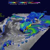
The GPM core observatory satellite flew above Kate on November 11, 2015 at 0926 UTC (4:26 a.m. EST) capturing data. Kate's maximum sustained winds were estimated at about 60 knots (69 mph) at that time making it a strong tropical storm. GPM's Dual-Frequency Precipitation Radar (DPR) sliced through Kate's western side and found that intense storms within feeder bands there were dropping rain at a rate of over 80 mm (3.1 inches) per hour. A 3-D cross section by GPM's Radar (DPR Ku Band) through Kate's weak eye showed intense storms swirling around the northern side of the tropical cyclone. GPM is managed by both NASA and the Japan Aerospace Exploration Agency.
Kate merged with a baroclinic zone over the north Atlantic and became an extra-tropical cyclone on November 12, 2015. A baroclinic zone is a region in which a temperature gradient exists on a constant pressure surface. Baroclinic zones are favored areas for strengthening and weakening system.
On Nov. 12, the RapidScat instrument that flies aboard the International Space Station measured the surface winds associated with the low pressure area. RapidScat showed that strongest winds were in the northwestern and southeastern quadrants near 32 meters per second (71.5 mph/115.2 kph). Winds around the southwestern quadrant were weakest, while the northeastern side of the storm averaged wind speeds around 20 meters per second (44.7 mph/72 kph).
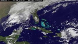
On Nov. 13 at 1145 UTC (7:45 a.m. EST), the NOAA's GOES-East satellite saw the low pressure system formerly known as extra-tropical storm Kate was in the Northern Atlantic Ocean, far to the south of Greenland. An image of the storm was created by the NASA/NOAA GOES Project at NASA's Goddard Space Flight Center in Greenbelt, Maryland. The image showed the low pressure center near 41 degrees north latitude and 47 degrees west longitude, and clouds associated with the cold front stretched south and west of the center toward the Bahamas. The low pressure center and associated cold front continued tracking to the east, across the Atlantic.
Nov. 09, 2015 - NASA Sees Tropical Storm Kate Form, Bahamas Under Warning
NASA's Terra satellite saw the Atlantic Ocean's twelfth tropical depression as it was forming, and an animation of NOAA's GOES-East satellite data showed its development into Tropical Storm Kate near the Bahamas.
On November 9, 2015 a Tropical Storm Warning was in effect for the central and northwestern Bahamas.
On Nov. 8, 2015 the Moderate Resolution Imaging Spectroradiometer or MODIS instrument aboard NASA's Terra satellite captured a visible image of newborn Tropical Depression 12 in the western Atlantic. Kate formed as a tropical depression at 10 p.m. EST on Nov. 8 about 115 miles (190 km) southeast of San Salvador.
At 8:20 a.m. EST, Air Force Reserve hurricane hunter aircraft data indicated that Tropical Depression Twelve has strengthened to Tropical Storm Kate. The maximum sustained winds at that time were estimated to be 40 mph (65 kph) with higher gusts.
A 43 second animation of infrared and visible imagery from NOAA's GOES-East satellite over the period of satellite from Nov. 7 to 9 shows the development and movement of Tropical Storm Kate to the Bahamas. The animation was created by the NASA/NOAA GOES Project at NASA Goddard.
At 10 a.m. EST (1500 UTC) on November 9, 2015 the center of Tropical Storm Kate was located near latitude 24.5 North, longitude 75.3 West. That's just 15 miles (25 km) east-northeast of Cat Island an about 170 miles (275 km) southeast of Great Abaco Island.
Kate was moving toward the northwest near 15 mph (24 kph). The National Hurricane Center (NHC) expects Kate to turn toward the north, followed by a turn toward the north-northeast on Tuesday, November 10. Maximum sustained winds had increased to near 45 mph (75 kph) and additional strengthening is forecast during the next two days. The estimated minimum central pressure based on data from an Air Force Reserve reconnaissance aircraft is 1008 millibars.
Because the central and northwestern Bahamas are under a tropical storm warning, the National Hurricane Center said total rain accumulations of 1 to 3 inches over the Bahamas through tonight, November 3.
Nov. 10, 2015 - NASA Spots Kate Speeding Away from the Bahamas
NASA-NOAA's Suomi NPP satellite and NOAA's GOES-East satellite both saw strong thunderstorms circling Tropical Storm Kate's center of circulation as the storm sped away from the Bahamas.
A visible image Tropical Storm Kate near Bermuda was taken from NOAA's GOES-East satellite at 1430 UTC (9:30 a.m. EDT). The GOES-East image showed the concentration of thunderstorms around the center, which is covered by a small central dense overcast, and a fragmented band of thunderstorms northeast of the center.
When NASA-NOAA's Suomi NPP satellite passed over Kate at 7:00 UTC (2 a.m. EST) the Visible Infrared Imaging Radiometer Suite or VIIRS instrument that flies aboard looked at the storm in infrared light. Cloud top temperatures of thunderstorms around the eyewall were between minus 70 and minus 80 degrees Celsius/minus 94 and minus 112 degrees Fahrenheit.
The higher the cloud tops, the colder they are as temperatures get colder with altitude in the troposphere. Storms with cloud top temperatures that cold have the capability of generating heavy rainfall.
At 10 a.m. EST (1500 UTC) on Nov. 10, the center of Tropical Storm Kate was located near latitude 30.2 North, longitude 74.7 West. That's about 350 miles (560 km) south of Cape Hatteras, North Carolina and 600 miles (970 km) west of Bermuda.
Kate was moving toward the northeast near 21 mph (33 kph), and the National Hurricane Center expects that general motion is expected to continue today with an increase in forward speed. On the forecast track, the center of Kate is expected to remain well offshore of the U.S. East Coast and pass north of Bermuda tonight and early Wednesday, November 11. Data from an Air Force Reserve Hurricane Hunter aircraft indicated that maximum sustained winds have increased to near 70 mph (110 kph) and Kate is forecast to become a hurricane at night on November 10. The latest minimum central pressure based on data from the aircraft is 999 millibars.
NHC forecasts Kate to turn northeastward and east-northeastward and accelerate more through Wednesday as it becomes embedded in the mid-latitude westerlies and speed into the North Atlantic. For forecast updates, visit the NHC website: www.nhc.noaa.gov.
Nov. 12, 2015 - NASA Spies Extra-tropical Storm Kate Racing Through North Atlantic
On November 12 at 4 a.m. EST the National Hurricane Center issued the last advisory on Extra-Tropical Cyclone Kate, located several hundred miles south-southeast of Cape Race, Newfoundland. NOAA's GOES-East satellite captured a visible light image of the storm.
A NOAA GOES-West satellite visible image extra-tropical storm Kate on Nov. 12 at 1445 UTC (9:45 a.m. EST) showed the storm over 400 miles southeast of Newfoundland, Canada. Most of the clouds associated with the post-tropical storm were north and east of the center. Forecaster Beven of the National Hurricane Center said, "Satellite imagery indicates that Kate has merged with a baroclinic zone over the north Atlantic and is now an extratropical cyclone."
Kate Reached Hurricane Strength
On Nov. 10, the RapidScat instrument that flies aboard the International Space Station saw Hurricane Kate north of the Bahamas and its strongest winds were north of the center. Maximum sustained winds in both areas were as strong as 30 meters per second (67 mph/108 kph). On Nov. 11, those winds increased to hurricane force. Hurricane force winds extended outward up to 35 miles (55 km) from the center and tropical storm force winds extend outward up to 205 miles (335 km).
At 10 a.m. EST (1500 UTC) on Nov. 11 the center of Hurricane Kate was located near latitude 36.8 North, longitude 60.5 West. That put Kate's center about 395 miles (635 km) northeast of Bermuda and about 780 miles (1,260 km) south-southwest of Cape Race Newfoundland.
An Infrared Look at Kate
On Nov. 12 at 05:17 UTC (12:17 a.m. EST) infrared imagery from the Atmospheric Infrared Sounder or AIRS instrument aboard NASA's Aqua satellite showed fragmented strong storms east and north of Kate's center where cold cloud top temperatures were near -63F/-53C. Storms with cloud tops that cold (and high in the troposphere) have been shown to generate heavy rain.
Kate Weakens and Becomes Extra-Tropical
At 4 a.m. EST on Nov. 12, Kate was classified as an extra-tropical storm. That means that a tropical cyclone has lost its "tropical" characteristics. The National Hurricane Center defines "extra-tropical" as a transition that implies both poleward displacement (meaning it moves toward the north or south pole) of the cyclone and the conversion of the cyclone's primary energy source from the release of latent heat of condensation to baroclinic (the temperature contrast between warm and cold air masses) processes. It is important to note that cyclones can become extratropical and still retain winds of hurricane or tropical storm force.
At 4 a.m. EST on Nov. 12, Kate's maximum sustained winds were near 60 knots (70 mph). Kate was centered near 40.7 degrees north latitude and 50.8 degrees west longitude, about 430 miles south-southeast of Cape Race, Newfoundland, Canada. Kate was moving to the east-northeast at 23 knots (26 mph). Minimum central pressure was 983 millibars. The post-tropical cyclone is expected to accelerate toward the east-northeast and northeast.
Kate's Fate
The National Hurricane Center expects extra-tropical storm Kate to continue weakening, but slowly over the next couple of days. The NHC forecast keeps maximum sustained winds near 45 knots (50 mph) through Nov. 15 and by Nov. 16, Kate is expected to become absorbed by an extra-tropical low pressure area.





 Italian
  Share
Share Share via mail
  Automotive
 Sport
Sport Events
 Art&Culture
 Design
 Fashion&Beauty
 Food&Hospitality
 Technology
 Nautica
 Racing
 Excellence
 Corporate
 OffBeat
 Green
Green Gift
Gift Pop
Pop Heritage
 Entertainment
 Health & Wellness